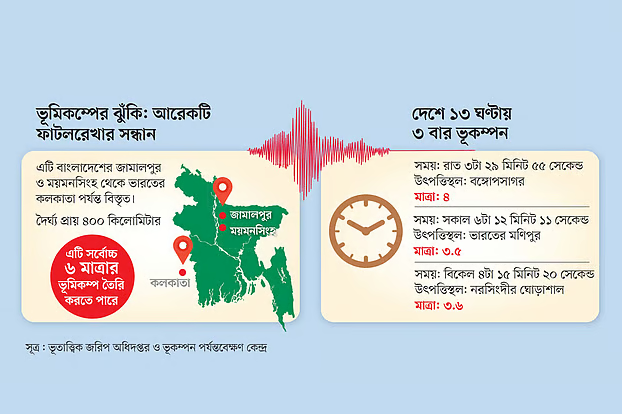
An international team of researchers has identified a previously unmapped active fault line running roughly 400km from Jamalpur and Mymensingh in Bangladesh to Kolkata in India, with segments capable of generating earthquakes of up to magnitude 6, according to early findings shared by the project leads.
The work—led by Akhtarul Ahsan, deputy director at the Bangladesh Geological Survey and a PhD researcher at Auburn University—adds a new structure to Bangladesh’s known seismic architecture, long dominated in risk assessments by the Dauki Fault and the Indo-Burma megathrust. Other mapped domestic faults include Sitakunda (coastal), Madhupur, Shahjibazar, Jaflong and Comilla.
Ahsan said his team began field and remote-sensing investigations in March 2024 using tectonic geomorphology techniques to trace landform changes tied to deep crustal movement. The fault has been subdivided into three segments with differing hazard profiles: one with lower expected magnitudes, a second with higher potential, and a third that appears inactive. Specific segment locations and parameters will be published after peer review, he added.
The group—comprising scientists from Bangladesh, the United States, France and Turkey—plans to present detailed results at the American Geophysical Union meeting in Louisiana from 14–19 December. A journal article is also in preparation. One of Ahsan’s co-advisers is geophysicist Michael S. Steckler of Columbia University’s Lamont-Doherty Earth Observatory.
Links to historic quakes and river shifts
Preliminary analysis suggests the newly identified structure may be associated with several historical events, including the 1885 “Bengal earthquake,” estimated at magnitude ~7 with an epicenter near Manikganj and heavy damage reported in Mymensingh. The team also notes a possible connection to a 1923 event (listed by the USGS catalog at magnitude 6.9) in the Mymensingh–Kishoreganj region.
Researchers say the fault’s activity correlates with documented shifts in the Brahmaputra River’s course—changes that are still occurring—underscoring the intertwined nature of tectonics and fluvial dynamics in the Bengal Basin.
Plate motion and reactivation timeline
The study frames the structure’s evolution within the larger collision between the Indian and Eurasian plates. The Indian Plate is currently moving beneath Eurasia at about 46 millimeters per year, though the direction and rate have varied over geologic time. According to the team’s reconstruction, the fault originated in the Eocene (~56 million years ago), remained largely quiescent through a ~23-million-year interval during the Miocene, and was reactivated roughly 5.6 million years ago as uplift accelerated across the Meghalaya highlands.
Caution, not alarm
Seismologists unaffiliated with the project urge measured interpretation. “Our geological reality includes many fault lines; further research will undoubtedly find more,” said Ashraful Alam, associate professor of geology at the University of Dhaka, who supported the study’s satellite-based mapping of morphological change. “The existence of a fault does not automatically imply high-magnitude earthquakes.”
AKM Khorshed Alam, former director general of the Geological Survey of Bangladesh and a quake-hazards specialist, called the use of tectonic geomorphology a credible approach for fault identification. The critical next steps, he said, are to quantify the fault’s extent, assess how much strain is accumulating, and estimate recurrence intervals—key inputs for hazard models and building-code updates.
Heightened public interest after recent tremors
The findings come amid renewed public concern following four tremors over 21–22 November, including a magnitude-5.7 quake that left 10 people dead and caused localized structural damage. While such events do not by themselves forecast larger shocks, they have spotlighted Dhaka’s vulnerability and the need for rigorous enforcement of seismic design standards.
Ahsan emphasized that the team will disclose segment-level hazard assessments after peer review and conference presentation. “We want the science to be precise and useful for planners and engineers,” he said, noting that the work is meant to complement—not replace—existing national seismic zonation and risk-reduction efforts.
For now, experts recommend that authorities and the public treat the discovery as a prompt to accelerate practical measures already on the table: retrofitting critical infrastructure, enforcing building codes, keeping evacuation routes clear, and strengthening emergency response capacity.